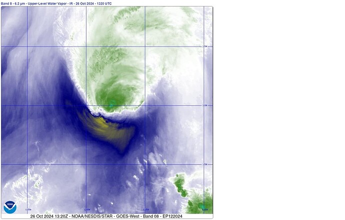
With Hurricane Kristy still some distance from landfall, I will be intently watching NOAA Band 08 (Upper Troposphere Moisture) for signs of control: steering, pausing, strengthening, etc. I hope other readers here will sit down and watch as well.
Kristy NOAA Band 08 (240 imgs, 40-hrs) (high bandwidth internet)
Kristy NOAA Band 08 (24 images, 4 hrs)
STEERING: Telltale signs of expected course change to the north are now present–increasing dryness (appears as dark blue, yellow and orange in Band-08 imagery) have developed below the now-wobbling hurricane. These dry regions are indication and/or cause for the moisture-laden air mass to change direction; they may even be propelling it. At minimum, the regions will form a no-go boundary to limit travel to the west and south.
I contend this kind of steering is a top-down weather control operation as opposed other levers (NORAD, lasers, etc.) which cause rotation and the endless new explosions of columnar, cold, water vapor. Those levers could be from aircraft, ships, distant land stations, satellites, etc. Doesn’t matter.
OTHER PHENOMENA:
If I understand correctly, hurricanes should be a bottom-up, vertically homogenous, cyclonic (as in rotating) mass.
So, change the Band and Loop setting, and watch for other phenomena:
- Straight lines of water vapor, visible clouds, energy dissipation (lightning, rapidly rising cold air masses, etc.)
- Waves emanating outward from the center of the storm
- Random radial explosions of colder water vapor that do not rotate with the storm
- Appearance of lines of clouds that do not emanate from the storm.
- Where and when lightning appears, such as being synchronized with lightning discharges of distant clouds
- Air mass color differences
- Evidence of unsynchronized, two-tier operation:
(lower clouds look like a spiral hurricane)
(upper clouds look like boiling soup)
When will it wobble and when will it spin Cat-5 fast with a sphincter-tight eyewall? Will they make it our first-ever Cat-6? What other climate change and new weather narratives will be pitched ahead of time?
I suggest opening a browser tab and watch this thing from time to time. I am not making predictions other than to say, each storm seems to reflect improved control and design over previous ones. AI anyone?


 We had a tornado touchdown here in my trailer park a few months ago. Took out the back end of one lady’s trailer, took off the very tip of a neighbor’s tree that hit the side of my trailer! All this flooding going on w/w is off the charts!!