Snake and Columbia river dams

White House weighs in on Lower Snake River dam breaching in unusual power play

July 12, 2022 at 6:00 am Updated July 12, 2022 at 4:30 pm

https://www.seattletimes.com/seattle-news/environment/white-house-weighs-in-on-lower-snake-river-dam-breaching-in-unusual-power-play/

1 of 2 | Salmon must pass several dams, such as the Lower Monumental Dam, to reach spawning grounds on the Snake River, an obstacle… (Steve Ringman / The Seattle Times)More

The Lower Granite Dam on the Snake River is one of several that could be removed, according to the Biden Administration.

By Lynda V. Mapes

Seattle Times environment reporter

The Biden administration released two reports in support of dam removal on the Lower Snake River citing the feasibility of replacing energy produced by the dams and the need for salmon recovery.

The reports were made public at 6 a.m. Tuesday and are sure to turn up the volume on the dam removal debate roiling the region. The release by the Council on Environmental Quality on behalf of four agencies inserts the Biden administration more prominently into what has been a largely regional issue.

The administration also weighed in on the dam removal debate last March in a blog post signed by multiple top agency officials that — while not taking a position on dam removal — took note of the call by Native tribes for dam removal and of the loss of salmon in the rivers.

The draft report Rebuilding Interior Columbia Basin Salmon and Steelhead by scientists at the National Oceanic and Atmospheric Administration found sweeping changes are needed to restore salmon to fishable levels, from removal of one to four dams on the Lower Snake to reintroduction of salmon to areas entirely blocked by dams.

“Business as usual will not restore the health and abundance of Pacific Northwest salmon. We need a durable, inclusive and regionally crafted long-term strategy for the management of the Columbia River Basin,” said CEQ Chair Brenda Mallory, who is coordinating a federal interagency effort, launched in October 2021, to develop information and analyses in support of federal and regional decision-making in the Columbia River System.

“These two reports add to the picture — that we are working alongside regional leaders to develop — of what it will take over the decades ahead to restore salmon populations, honor our commitments to Tribal Nations, deliver clean power and meet the many needs of stakeholders across the region.”

The report relied in part on science from the Nez Perce Tribe and state of Oregon, in addition to federal research by NOAA and U.S. Fish and Wildlife Service scientists.

GOP members of Congress from around the region blasted the reports.

“Today’s release of two reports from the Biden administration’s Council on Environmental Quality (CEQ) confirms what we have suspected for some time — they are cherry picking points to justify breaching the Lower Snake River Dams, which will permanently and negatively impact our way of life in the Pacific Northwest,” the lawmakers stated in a joint news release issued by Representatives Cathy McMorris Rodgers (WA-05), Dan Newhouse (WA-03), Jaime Herrera Beutler (WA-03), Cliff Bentz (OR-02), Russ Fulcher (ID-01), and Matt Rosendale (MT-AL).

Today, 13 runs of salmon and steelhead are at risk of extinction in the Columbia and Snake rivers as runs have declined to a fraction of historic abundance. Salmon in the Snake Basin are particularly hard-hit with only about 50 fish coming back to some drainages in an area that used to produce half the chinook salmon in the Columbia Basin.

The region has spent more than $24 billion in ratepayer money from 1980-2018 on salmon and steelhead recovery, but the fish continue to decline. It is time for a big step outside the status quo, according to the report. Dam breaching has long been opposed by grain shippers, irrigators, power producers and other industrial river users.

But recovery isn’t happening despite efforts like habitat restoration, massive hatchery releases and passage fixes at the dams.

“We need to go to larger-scale actions,” NOAA scientist Chris Jordan said in a briefing on the report Monday.

“We are at a crucial moment for salmon and steelhead in the Columbia River Basin when we’re seeing the impacts of climate change on top of other stressors, and this draft report delivers our scientific assessment of what we must do to make progress toward rebuilding the ‘healthy and harvestable’ fish populations in the Columbia Basin” said Janet Coit, assistant administrator for NOAA Fisheries.

The report on replacement power, commissioned by the U.S. Department of Energy’s Bonneville Power Administration and conducted by the private consulting firm E3, put an $11 billion-$19 billion price tag on the cost of replacing power from the dams. The range in cost depends on the method and the time frame. The cost estimates are within the range of other similar reports.

“E3’s energy analysis confirms what several other studies have shown: We can develop a portfolio of clean energy resources that replaces the output of the dams,” said Nancy Hirsh, Executive Director of the NW Energy Coalition. “The big difference among the studies is primarily about how to optimize the replacement portfolio to meet the common goals for reliability and affordability, not about actual feasibility.”

The administration has not endorsed the actions in the reports, but it is “carefully considering this information and ongoing regional efforts as it assesses long-term pathways for the Columbia River Basin,” the news release on the reports stated.

Some in the region heralded the reports.

“The information that is being developed confirms much of what we have been saying for a long time,” said Joseph Bogaard, executive director of the Save Our Wild Salmon Coalition. “The dams are replaceable. We need a political solution. Salmon are in deep trouble and we need to move quickly.”

After more than two decades of court battles and debates over the Lower Snake River dams, the reports add to momentum for removal, Bogaard said**,** even though the Biden administration has yet to take a position.

“The conversation has significantly advanced, accelerated and diversified,” Bogaard said.

Kurt Miller, executive director of Northwest RiverPartners, which represents utilities, shippers and other industrial river users, was skeptical of the findings. With chinook salmon in decline throughout the West Coast region — including on some undammed rivers — he disagreed dams were the main issue in recovery. Reducing the amount of hydropower generation also could lead to greater reliance on fossil fuel and stoke global warming that is a grave risk to salmon, Miller said.

“This feels more politically motivated than scientific**,**” Miller said. “Unfortunately, we have no confidence in this latest report from NOAA Fisheries.”

He added that it contradicts other peer-reviewed work NOAA has published and relies on scientific input from groups that have been engaged in efforts to remove the dams for years.

GOP Congressman Mike Simpson of Idaho kicked the dam removal bees’ nest in 2021, by putting a $34 billion price on removal and replacement of the dams’ services in order to save salmon. Now U.S. Sen. Patty Murray, a Democrat, and Washington Governor Jay Inslee also are taking stock of comments on another report on dam removal, with their recommendation expected later this summer.

The reports come as tribes and their allies are heading to Washington, D.C. to advocate for dam removal on the Lower Snake to boost recovery of salmon and endangered southern resident orcas, which rely on salmon for their diet.

So do tribes, who are suffering ill health because of the loss of their traditional foods, including salmon, said Andrew Joseph Jr., chair of the Confederated Tribes of the Colville Reservation, where salmon passage is blocked by the Chief Joseph and Grand Coulee dams.

“Our bodies were made for eating that salmon,” Joseph said. “For thousands of years**,** it was 80**%** of our diet. Now our immune system is weaker, and we have the worst health disparities.”

His family today has to travel two hours each way to try to catch salmon below Chief Joseph Dam.

The Nez Perce Tribe has long been at the forefront of the push for dam removal on the Lower Snake. Tribal Vice Chair Shannon Wheeler called the reports “definitely encouraging.”

“This administration is taking the climate crisis and the salmon extinction crisis seriously,” Wheeler said.

The report will be circulated to state and fish managers for review over the next 30 days. The report on replacement power will be considered at a public meeting of the Northwest Power and Conservation Council at 3:30 p.m. Tuesday that can be watched online.

Lynda V. Mapes: lmapes@seattletimes.com; on Twitter: @LyndaVMapes. Lynda specializes in coverage of the environment, natural history and Native American tribes.

3 Likes

Introduction and References of first report (DocumentCloud)

Rebuilding Interior Columbia Basin Salmon and Steelhead

Regional Fishery Co-manager Review Draft

v2.5 July 11, 2022

Introduction

Rebuilding salmon and steelhead stocks in the Columbia River Basin to levels that are healthy and harvestable requires careful consideration of the science that informs rebuilding strategies and actions. This document1 provides a high-level response to eight common questions about the science2 surrounding Columbia River basin salmon and steelhead rebuilding efforts. The questions and responses are meant to inform the broader discussion around the socio-economic factors and resources necessary to help these species recover.

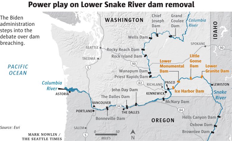
The scope of this analysis includes the clusters of populations, or stocks, of natural-origin Pacific salmon and steelhead originating above Bonneville Dam (i.e., in the interior Columbia River basin), as well as their life-cycle needs associated with freshwater, estuary, and marine habitats (Figure 1).

(A) (B)

Figure 1. Maps of the Columbia River basin. (A) shows areas a) currently occupied by anadromous salmon and steelhead (light green), b) historically used
by anadromous fish but currently inaccessible due to dams blocking fish passage (dark green), and

c) historically inaccessible due to natural migration barriers (light blue). (B) shows regional areas associated with stock delineations in this report (modified from NMFS 2020).

These stocks are critically important to Columbia River basin tribes, as well as to the economy and overall ecological health of the region. Despite their undisputed value, they have been negatively affected by extensive anthropogenic activity—in particular, the dams and reservoirs that form the Columbia River

1 This draft report was prepared by the National Oceanic and Atmospheric Administration, with input from and support of the U.S. Fish and Wildlife Service and input from scientists and fishery managers from the Nez Perce Tribe and State of Oregon. The draft will be circulated to state and Tribal co-managers for input before being finalized. Whenever possible, responses are informed by NMFS (2020), Phase 2 Report of the Columbia Basin Partnership Task Force of the Marine Fisheries Advisory Committee.

2 Does not consider socioeconomic or political science.

System3 (CRS; NAS 1996). The CRS has been the subject of decades of litigation regarding the effects on salmon and steelhead and modifications to their stream, river, floodplain, and estuary habitats. In addition, and as identified in the ESA Recovery Plans (NOAA 2017, UCSRB & NMFS 2007) as factors for listing and key areas of concern for recovery actions, historic and ongoing degradation of stream, river, floodplain, and estuary habitats severely limit the biological potential of all interior Columbia River basin stocks.

The goals of this analysis are to inform achieving the mid-range Columbia Basin Partnership (CBP)4
Task Force’s naturally produced adult salmon and steelhead abundance goals by 2050, and, by 2030, the Northwest Power and Conservation Council’s (NPCC 2020) productivity goals, as measured by smolt-to- adult return rates (SARs). These goals are commonly understood and referenced by fish managers and the public because of the transparent public processes used to establish them; they are reasonable quantitative targets that we embrace for the purposes of this analysis. Mid-range abundance goals exceed ESA recovery thresholds for abundance, and represent progress toward healthy and harvestable status of these stocks (NMFS 2020). The CBP low-, mid-, and high-range quantitative goals are all substantially greater than the ESA Section 7(a)(2) conservation standard of not likely jeopardizing the continued existence of listed species that is applied to federal agency actions in ESA Section 7(a)(2) consultations.

Achieving these fish-related goals would also provide the highest certainty for meeting multiple objectives that address tribal inequities, securing a pathway to harvestable abundance levels, and meeting ESA needs in the face of climate change (Figure 2).

Figure 2.

Conceptual abundance continuum of salmon and steelhead, aggregated across the 16 stocks (ESA listed and non- listed) upstream

of Bonneville
dam, relative to management thresholds and goals. Mid-range goals exceed ESA recovery abundance thresholds and represent progress toward high-range goals associated with healthy and harvestable status (NMFS 2020).

3 Fourteen federally owned and operated hydroelectric dams (projects) on the Columbia and Snake rivers, including: Libby, Hungry Horse, Albeni Falls, Grand Coulee, Chief Joseph, Dworshak, Lower Granite, Little Goose, Lower Monumental, Ice Harbor, McNary, John Day, The Dalles, and Bonneville.
4 NOAA Fisheries and its Marine Fisheries Advisory Committee (MAFAC) convened the CBP Task Force in 2017, bringing together diverse representatives from across the Columbia River basin to a) establish a common vision and goals for the basin and its salmon and steelhead (NMFS 2020), and b) establish urgency to achieve the agreed-upon high-range goals.

2

The criteria for species and area priorities include: 1) level of extinction risk, 2) current spatial structure and diversity, 3) importance to tribal communities, 4) habitats essential for life-cycle needs, and 5) resilience of habitat to climate change. Although they in no way reduce the importance of all extant and extirpated Columbia Basin native salmon and steelhead, the criteria allow for a broad-level analysis that helps provide a draft context for sequencing and prioritizing multifaceted, long-term, and complex rebuilding actions.

Bibliography:

Alden, W.C. 1953. Physiography and Glacial Geology of Western Montana and Adjacent Areas. US Geological Survey Professional Paper 231. 200 pp.

Anderson, N.L., Paszkowski, C.A., & G.A. Hood. 2015. Linking aquatic and terrestrial environments: can beaver canals serve as movement corridors for pond-breeding amphibians? Animal Conservation, 18, 287-294.

Barrows, M.G., Anglin, D.R., Sankovich, P.M., Hudson, J.M., Koch, R.C., Skalicky, J.J., Wills, D.A., & B.P. Silver. 2016. Use of the Mainstem Columbia and Lower Snake Rivers by Migratory Bull Trout: Data Synthesis and Analyses, Final Report. Vancouver, WA: U.S. Fish and Wildlife Service (USFWS).

Bellmore, J.R., & C.V. Baxter. 2014. Effects of Geomorphic Process Domains on River Ecosystems: A Comparison of Floodplain and Confined Valley Segments. River Research and Applications, 30(5), 617-630.

Bouwes, N., Weber, N., Jordan, C.E., Saunders W.C., Tattam, I.A., Volk, C., Wheaton, J.M., & M.M. Pollock. 2016. Ecosystem experiment reveals benefits of natural and simulated beaver dams to a threatened population of steelhead (Oncorhynchus mykiss). Sci. Rep. 6, 28581; doi: 10.1038/ srep28581.

Bowerman, T., Keefer, M.L., & C.C. Caudill. 2021. Elevated stream temperature, origin, and individual size influence Chinook salmon prespawn mortality across the Columbia River Basin. Fisheries Research 237:105874.

Brenkman, S.J., Peters, R.J., Tabor, R.A., Geffre, J.J., & K.T. Sutton. 2019. Rapid recolonization and life history responses of Bull Trout following dam removal in Washington’s Elwha River. North American Journal of Fisheries Management 39:560–573.

Bryson, G. E., Kidd, K. A., & K.M. Samways. 2022. Food web incorporation of marine-derived nutrients after the reintroduction of endangered inner Bay of Fundy Atlantic salmon (Salmo salar). Canadian Journal of Fisheries and Aquatic Sciences, 99(999), 1-8.

Caudill, C.C., Keefer, M.L., Clabough, T.S., Naughton, G.P., Burke, B.J., & C.A. Peery. 2013. Indirect effects of impoundment on migrating fish: temperature gradients in fish ladders slow dam passage by adult Chinook Salmon and steelhead. PLoS ONE 8:e85586. DOI: 10.1371/journal.pone.0085586. Fagan, W.F., Holmes, E.E., 2006. Quantifying the extinction vortex. Ecology Letters 9:51–60.

CBC (Columbia Basin Collaborative). 2020. Agreement between the states of Oregon, Washington, Idaho and Montana to define a future collaborative framework to analyze and discuss key issues related to salmon and steelhead with the purpose of increasing overall abundance. https://species.idaho.gov/ wp-content/uploads/2021/02/Four-State-Agreement-Columbia-River-Salmon-10-01-20.pdf.

CEQ (Council of Environmental Quality). 2022. White House Blog March 28, 2022. https://www. Columbia River Basin Fisheries: Working Together to Develop a Path Forward | The White House develop-a-path-forward/#_ftn2.

Crozier, L. G., Hendry, A.P., Lawson, P.W., Quinn, T.P., Mantua, N.J., Battin, J., Shaw, R.G., & R.B. Huey. 2008. Potential responses to climate change in organisms with complex life histories: evolution and plasticity in Pacific salmon. Evolutionary Applications 1:252-270.

Crozier, L.G., McClure, M.M., Beechie, T., Bograd, S.J., Boughton, D.A., Carr, M., Cooney, T.D., Dunham, J.B., Greene, C.M., Haltuch, M.A., Hazen, E.L., Holzer, D.M., Huff, D.D., Johnson, R.C., Jordan, C.E., Kaplan, I.C., Lindley, S.T., Mantua, N.J., Moyle, P.B., Myers, J.M., Nelson, M.W., Spence, B.C., Weitkamp, L.A., Williams, T.H., & E. Willis-Norton. 2019. Climate vulnerability assessment for Pacific salmon and steelhead in the California Current Large Marine Ecosystem: PLoS ONE, https://doi.org/10.1371/journal.pone.0217711.

21

Crozier, L.G., Siegel J.E., Wiesebron, L.E., Trujillo, E.M., Burke, B.J., Sandford, B.P., & D. L. Widener. 2020. Snake River sockeye and Chinook salmon in a changing climate: Implications for upstream migration survival during recent extreme and future climates. PLoS ONE 15(9): e0238886. https:// Snake River sockeye and Chinook salmon in a changing climate: Implications for upstream migration survival during recent extreme and future climates.

Crozier, L.G., Burke, B.J., Chasco, B.E., Widener, D.L., & R.W. Zabel. 2021. Climate change threatens Chinook salmon throughout their life cycle. Available at: https://www.nature.com/articles/s42003- 021-01734-w.pdf.

EPA (Environmental Protection Agency). 2020a. Columbia and Lower Snake Rivers Temperature Total Maximum Daily Load. U.S. Environmental Protection Agency, Seattle, WA. May 2020. Available at TMDL for Temperature in the Columbia and Lower Snake Rivers | US EPA.

EPA (Environmental Protection Agency). 2020b. Assessment of Impacts to Columbia and Snake River Temperatures using the RBM10 Model Scenario Report: Appendix D to the Columbia and Lower Snake Rivers Temperature Total Maximum Daily Load. U.S. Environmental Protection Agency, Seattle, WA. May 2020. Available at TMDL for Temperature in the Columbia and Lower Snake Rivers | US EPA.

EPA (Environmental Protection Agency). 2021. Columbia River Cold Water Refuges Plan. U.S. Environmental Protection Agency, Seattle, WA. January 2021. Available at https://www.epa.gov/ columbiariver/columbia-river-cold-water-refuges-plan.

Fagan, W.F., & E.E. Holmes. 2006. Quantifying the extinction vortex. Ecology Letters, 9:51-60.

Fish, F., & M. Hanavan. 1948. A report upon the Grand Coulee fish-maintenance project 1939-1947. Special Scientific Report No. 55, U.S. Fish and Wildlife Service, Washington, D.C.

Ford, M. J., editor. 2022. Biological Viability Assessment Update for Pacific Salmon and Steelhead Listed Under the Endangered Species Act: Pacific Northwest. U.S. Department of Commerce, NOAA Technical Memorandum NMFS-NWFSC-171. Biological Viability Assessment Update for Pacific Salmon and Steelhead Listed Under the Endangered Species Act: Pacific Northwest.

Francis, T.B., Schindler, D.E., & J.M. Moore. 2006. Aquatic insects play a minor role in dispersing salmon-derived nutrients into riparian forests in southwestern Alaska. Canadian Journal of Fisheries and Aquatic Sciences, 63(11), 2543-2552.

Gende, S.M., Edwards, R.T., Willson, M.F., & M.S. Wipfli. 2002. Pacific salmon in aquatic and terrestrial ecosystems: Pacific salmon subsidize freshwater and terrestrial ecosystems through several pathways, which generates unique management and conservation issues but also provides valuable research opportunities. BioScience, 52(10), 917-928.

Gilpin, M.E., & M.E. Soulé. 1986. Minimum viable populations: processes of species extinction. Pages 19–34 in Soulé, M.E. (Ed.), Conservation Biology: The Science of Scarcity and Diversity. Sinauer, Sunderland, MA.

ISAB (Independent Scientific Advisory Board), 2007. Climate change impacts on Columbia River basin fish and wildlife. https://www.nwcouncil.org/sites/default/files/isab2007_2.pdf.

Isaak, D.J., Luce, C.H., Horan, D.L., Chandler, G.L., Wollrab, S.P., & D.E. Nagel. 2018. Global warming of salmon and trout rivers in the northwestern U.S.: road to ruin or path through purgatory? Transactions of the American Fisheries Society 147:566–587.

Jordan, C.E. & E. Fairfax. (2022) Beaver: the North American freshwater climate action plan. Wiley Interdisciplinary Reviews Water, 1–13. https://doi.org/10.1002/wat2.1592

Jorgensen, J.C., Nicol C., Fogel C., & T.J. Beechie. 2021. Identifying the potential of anadromous salmonid habitat restoration with life cycle models. PLoS ONE 16(9): e0256792.

Kocik, J. F., Hayes, S. A., Carlson, S. M. & B. Cluer. (2022). A Resist-Accept-Direct (RAD) future for Salmon in Maine and California: Salmon at the southern edge. Fisheries Management and Ecology, 00, 1–19. https://doi.org/10.1111/fme.12575

22

Mathewson, D.D., Hocking, M.D., & T.E. Reimchen. 2003. Nitrogen uptake in riparian plant communities across a sharp ecological boundary of salmon density. BMC ecology, 3(1), 1-11.

McCann, J., Chockley, B., Cooper, E., Hsu, B., Haeseker, S., Lessard, R., Petrosky, C., Copeland, T., Tinus, E., Storch, A., & D. Rawding. 2018. Comparative survival study (CSS) of PIT-tagged spring/ summer/fall Chinook, summer steelhead and Sockeye. Annual Report to the Bonneville Power Administration, Contract 19960200, Portland, OR. https://www.fpc.org/documents/CSS/2018-CSS- Report-Fix.pdf.

McElhany, P., Rucklelshaus, M., Ford, M., Wainwright, T., & E. Bjorkstedt. 2000. Viable salmonid populations and the recovery of evolutionarily significant units. Northwest Fisheries Science Center, NOAA Technical Memorandum NMFS-NWFSC-42. Viable salmonid populations and the recovery of evolutionarily significant units.

National Academy of Sciences (NAS). 1996. Upstream: Salmon and Society in the Pacific Northwest. National Academy Press, Washington D.C.

NMFS (National Marine Fisheries Service). 2020. A vision for salmon and steelhead: goals to restore thriving salmon and steelhead to the Columbia River basin. Phase 2 report of the Columbia
River Partnership Task Force of the Marine Fisheries Advisory Committee. Portland, OR. https:// s3.amazonaws.com/media.fisheries.noaa.gov/2020-10/MAFAC_CRB_Phase2ReportFinal_508.pdf?null.

NOAA (National Oceanic and Atmospheric Administration). 2017. ESA Snake River Fall Chinook Salmon Recovery Plan. Portland, OR. https://media.fisheries.noaa.gov/dam-migration/final-snake- river-fall-chinook-salmon-recovery-plan-2017.pdf.

NOAA (National Oceanic and Atmospheric Administration). 2022. Ocean Conditions Indicators Trends web page. Ocean Conditions Indicators Trends | NOAA Fisheries.

NPCC (Northwest Power and Conservation Council). 2020. Columbia River Basin Fish and Wildlife Program 2014: The 2020 Addendum. NPCC Report 2020-9. Available by download from: https:// 2020 Addendum to the 2014 Columbia River Basin Fish and Wildlife Program.

Nummi, P., Liao, W., van der Schoor, J., & J. Loehr. 2021. Beaver creates early successional hotspots for water beetles. Biodiversity and Conservation, 30(10), 2655-2670.

ODFW (Oregon Department of Fish and Wildlife). 2020. Coastal, Columbia, and Snake conservation plan for lampreys in Oregon: Pacific Lamprey, Western River Lamprey, Western Brook Lamprey, and Pacific Brook Lamprey. https://www.dfw.state.or.us/ fish/CRP/coastal_columbia_snake_lamprey_ plan.asp.

Petrosky, C.E., Schaller, H.A., Tinus, E.S., Copeland, T., & A.J. Storch. 2020. Achieving productivity to recover and restore Columbia River stream‐type Chinook Salmon relies on increasing smolt‐to‐adult survival. North American Journal of Fisheries Management 40:789–803.

Philip, S.Y., Kew, S.F., van Oldenborgh, G.J., Anslow, F.S., Seneviratne, S.I., Vautard, R., Coumou, D., Ebi, K.L., Arrighi, J., Singh, R., van Aalst, M., Pereira Marghidan, C., Wehner, M., Yang, W., Li, S., Schumacher, D.L., Hauser, M., Bonnet, R., Luu, L.N., Lehner, F., Gillett, N., Tradowsky, J., Vecchi, G.A., Rodell, C., Stull, R.B., Howard, R., & F.E.L. Otto. 2021. Rapid attribution analysis of the extraordinary heatwave on the Pacific Coast of the US and Canada. Earth Syst. Dynam. DOI: 10.5194/esd-2021-90.

Scott, M.H. 2020. Statistical Modeling of Historical Daily Water Temperatures in the Lower Columbia River. 2020. Dissertations and Theses. Paper 5594."Statistical Modeling of Historical Daily Water Temperatures in the Low" by Malia Hanae Scott

Simberloff, D. 1988. The contribution of population and community biology to conservation science. Annual Review of Ecological Systems 19:473–511.

Skidmore, P., & J.M. Wheaton. 2022. Natural infrastructure—Can restored riverscapes help us adapt to climate change. Anthropocene. https://doi.org/10.13140/RG.2.2.33525.86248.

23

Storch, A.J., H.A. Schaller, C.E. Petrosky, R.L. Vadas, B.J. Clemens, G. Sprague, N. Mercado-
Silva, B. Roper, M.J. Parsley, E. Bowles, R.M. Hughes, & J.A. Hesse. 2022. A review of
potential conservation and fisheries benefits of breaching four dams in the Lower Snake River (Washington, USA). Water Biology and Security. 100030, ISSN 2772-7351, https://doi.org/10.1016/j. watbs.2022.100030. (A review of potential conservation and fisheries benefits of breaching four dams in the Lower Snake River (Washington, USA) - ScienceDirect).

Tonina, D., McKean, J. A., Isaak, D.,Benjankar, R. M., Tang, C., & Q. Chen. (2022). Climate change shrinks and fragments salmon habitats in a snow dependent region. Geophysical Research Letters, 49, e2022GL098552. https://doi.org/10.1029/2022GL098552

Tonra, C.M., Sager-Fradkin, K., Morley, S.A., Duda, J.J., & P.P. Marra. 2015. The rapid return of marine- derived nutrients to a freshwater food web following dam removal. Biological Conservation, 192, 130-134.

UCSRB & NMFS (Upper Columbia Salmon Recovery Board, National Marine Fisheries Service). 2007. Upper Columbia Spring Chinook Salmon and Steelhead Recovery Plan https://repository.library. noaa.gov/view/noaa/15990

UCUT (Upper Columbia United Tribes). 2019. Fish passage and reintroduction Phase 1 Report: Investigations upstream of Chief Joseph and Grand Coulee dams. Upper Columbia United Tribes, Spokane, WA. 154 p.

USFWS (U. S. Fish and Wildlife Service). 1999. Recovery Plan for the White Sturgeon (Acipenser transmontanus): Kootenai River Population. U.S. Fish and Wildlife Service, Portland, OR. 96 pp. plus appendices.

USFWS (U. S. Fish and Wildlife Service). 2015. Recovery Plan for the Coterminous United States Population of Bull Trout (Salvelinus confluentus). Portland, OR. Pacific | U.S. Fish & Wildlife Service bulltrout/pdf/Final_Bull_Trout_Recovery_Plan_092915.pdf.

Williams, B.K., Szaro, R.C., & C.D. Shapiro. 2009. Adaptive Management: The U.S. Department of the Interior Technical Guide. Adaptive Management Working Group, U.S. Department of the Interior, Washington, DC. ISBN:978-1-4133-2478-7.

Wohl, E., Lininger, K.B., & D.N. Scott. 2017. River beads as a conceptual framework for building carbon storage and resilience to extreme climate events into river management. Biogeochemistry, 141(3), 365–383.

Wohl, E., Castro, J., Cluer, B., Merritts, D., Powers, P., Staab, B., & C. Thorne. 2021. Rediscovering, reevaluating, and restoring lost river-wetland corridors. Frontiers in Earth Science, 9, 511.

Zabel, R.W. & C.E. Jordan (eds). 2020. Life Cycle Models of Interior Columbia River Basin Spring/ Summer-Run Chinook Salmon Populations. U.S. Dept. Commer. NOAA Tech. Memo. NMFS- NWFSC-156. Life Cycle Models of Interior Columbia River Basin Spring/Summer-Run Chinook Salmon Populations.

1 Like

Second report: The report on replacement power,

Executive Summary

E3 was contracted by the Bonneville Power Administration to conduct an independent study of the value of the lower Snake River dams (“LSR dams”) to the Northwest power system. The dams provide approximately 3,500 megawatts (“MW”) of total capacity1 and approximately 2,300 MW of firm peaking capability2 to support regional reliability. They also generate approximately 900 average MW of zero- carbon energy each year3, provide essential grid services such as operating reserves and voltage support, and operational flexibility to support renewable integration. If the dams are breached, these power services will need to be replaced to ensure the Northwest power system can continue to provide reliable electricity service. Replacing the dams is complicated by the clean energy policies adopted either statutorily or voluntarily by jurisdictions and utilities throughout the region, which will necessitate a transformation of the power system over time toward non-emitting resources even as electricity demand grows substantially due to electrification of the transportation and building sectors. This study uses E3’s Northwest RESOLVE model to study optimal capacity expansion scenarios with and without the lower Snake River dams, to determine the replacement resources and cost impacts to replace the dams’ power output. RESOLVE is an optimal capacity expansion and dispatch model that determines a least-cost set of investment and operational strategies to enable the “Core Northwest” region – consisting of Washington, Oregon, Northern Idaho, and Western Montana – to achieve its long-term clean energy policy goals at least-cost, while ensuring resource adequacy and operational reliability. RESOLVE has been used in several prior studies of electricity sector decarbonization in the Pacific Northwest4. Using RESOLVE allows for a dynamic optimization that considers replacement resource needs in the context of long-term system load and policy drivers, not just the near-term resource mix and needs of the system today. The dams are assumed to be breached in 2032, except for one sensitivity that considered 2024 breaching.

1 Like

Thanks very much for this, Bahri. I hope to be able to sort through the information soon.

1 Like

As for feasability( of sustainable energy production) of replaceability[ the study that was not done] , a couple of million Indians( or even better, slaves of any ethnicity) treading exercise bicycles with dynamos attached should do the trick. After all, it worked in ancient Rome.
Of course, Rome burned down. And even now, the ghost of Nero fiddles again.

1 Like

Basically the feds are just saying they are in support of taking out the dams.

A lot of the power is being exported to Canada, and a lot of the dams have fish ladders that the fish are fine with. Taking out the dams isn’t necessary for the Salmon to repopulate but they need to build ladders for the fish.

3 Likes

Here is some history about when the Ice Dams failed they caused many great floods: Missoula floods - Wikipedia

The Missoula floods (also known as the Spokane floods or the Bretz floods or Bretz’s floods) were cataclysmic glacial lake outburst floods that swept periodically across eastern Washington and down the Columbia River Gorge at the end of the last ice age. These floods were the result of periodic sudden ruptures of the ice dam on the Clark Fork River that created Glacial Lake Missoula. After each ice dam rupture, the waters of the lake would rush down the Clark Fork and the Columbia River, flooding much of eastern Washington and the Willamette Valley in western Oregon. After the lake drained, the ice would reform, creating Glacial Lake Missoula again.

These floods have been researched since the 1920s. During the last deglaciation that followed the end of the Last Glacial Maximum, geologists estimate that a cycle of flooding and reformation of the lake lasted an average of 55 years and that the floods occurred several times over the 2,000-year period between 15,000 and 13,000 years ago. U.S. Geological Survey hydrologist Jim O’Connor and Museo Nacional de Ciencias Naturales scientist Gerardo Benito have found evidence of at least twenty-five massive floods, the largest discharging about 10 cubic kilometers per hour (2.7 million m³/s, 13 times that of the Amazon River).[1] Alternate estimates for the peak flow rate of the largest flood include 17 cubic kilometers per hour[2] and range up to 60 cubic kilometers per hour.[3] The maximum flow speed approached 36 meters/second (130 km/h or 80 mph).[2]

Within the Columbia River drainage basin, detailed investigation of the Missoula floods’ glaciofluvial deposits, informally known as the Hanford formation, has documented the presence of Middle and Early Pleistocene Missoula flood deposits within the Othello Channels, Columbia River Gorge, Channeled Scabland, Quincy Basin, Pasco Basin, and the Walla Walla Valley. Based on the presence of multiple interglacial calcretes interbedded with flood deposits, magnetostratigraphy, optically stimulated luminescence dating, and unconformity truncated clastic dikes, it has been estimated that the oldest of the Pleistocene Missoula floods happened before 1.5 million years ago. Because of the fragmentary nature of older glaciofluvial deposits, which have been largely removed by subsequent Missoula floods, within the Hanford formation, the exact number of older Missoula floods, which are known as ancient cataclysmic floods, that occurred during the Pleistocene cannot be estimated with any confidence.[4][5]

Contents

Flood hypothesis proposed

Giant ripple marks at Markle Pass near Camas Hot Springs, Montana, U.S. View towards the northwest.

Geologist J Harlen Bretz first recognized evidence of the catastrophic floods, which he called the Spokane floods, in the 1920s. He was researching the Channeled Scablands in Eastern Washington, the Columbia Gorge, and the Willamette Valley of Oregon. In the summer of 1922, and for the next seven years, Bretz conducted field research of the Columbia River Plateau. He had been interested in unusual erosion features in the area since 1910 after seeing a newly published topographic map of the Potholes Cataract. Bretz coined the term Channeled Scablands in 1923 to refer to the area near the Grand Coulee, where massive erosion had cut through basalt deposits. Bretz published a paper in 1923, arguing that the Channeled Scablands in Eastern Washington were caused by massive flooding in the distant past.

Bretz’s view, which was seen as arguing for a catastrophic explanation of the geology, ran against the prevailing view of uniformitarianism, and Bretz’s views were initially disregarded. The Geological Society of Washington, D.C, invited the young Bretz to present his previously published research at a January 12, 1927 meeting where several other geologists presented competing theories. Another geologist at the meeting, J.T. Pardee, had worked with Bretz and had evidence of an ancient glacial lake that lent credence to Bretz’s theories. Bretz defended his theories, and this kicked off an acrimonious 40-year debate over the origin of the Scablands. Both Pardee and Bretz continued their research over the next 30 years, collecting and analyzing evidence that led them to identify Lake Missoula as the source of the Spokane flood and creator of the channeled scablands.[6][7]

After Pardee studied the canyon of the Flathead River, he estimated that flood waters in excess of 45 miles per hour (72 km/h) would be required to roll the largest of the boulders moved by the flood. He estimated the water flow was 9 cubic miles per hour (38 km3/h), more than the combined flow of every river in the world.[8] More recent estimates place the flow rate at ten times the flow of all current rivers combined.[2]

The Missoula floods have also been referred to as the Bretz floods in honor of Bretz.[3]

Flood initiation

Cordilleran ice sheet

maximum extent of Glacial Lake Missoula (eastern) and Glacial Lake Columbia (western)

areas swept by Missoula and Columbia floods

As the depth of the water in Lake Missoula increased, the pressure at the bottom of the ice dam increased enough to lower the freezing point of water below the temperature of the ice forming the dam. This allowed liquid water to seep into minuscule cracks present in the ice dam.[citation needed] Over a period of time, the friction from water flowing through these cracks generated enough heat to melt the ice walls and enlarge the cracks. This allowed more water to flow through the cracks, generating more heat, allowing even more water to flow through the cracks.[citation needed] This feedback cycle eventually weakened the ice dam so much that it could no longer support the pressure of the water behind it, and it failed catastrophically.[9] This process is known as a glacial lake outburst flood, and there is evidence that many such events occurred in the distant past.

Flood events

As the water emerged from the Columbia River gorge, it backed up again at the 1 mile (1.6 km) wide narrows near Kalama, Washington. Some temporary lakes rose to an elevation of more than 400 ft (120 m), flooding the Willamette Valley to Eugene, Oregon and beyond. Iceberg-rafted glacial erratics and erosion features are evidence of these events. Lake-bottom sediments deposited by the floods have contributed to the agricultural richness of the Willamette and Columbia Valleys. Glacial deposits overlaid with centuries of windblown sediments (loess) have scattered steep, southerly sloping dunes throughout the Columbia Valley, ideal conditions for orchard and vineyard development at higher latitudes.

After analysis and controversy, geologists now believe that there were 40 or more separate floods, although the exact source of the water is still being debated. The peak flow of the floods is estimated to be 40 to 60 cubic kilometers per hour (9.5 to 15 cubic miles per hour).[2][3] The maximum flow speed approached 36 meters/second (130 km/h or 80 mph).[2] Up to 1.9×10¹⁹ joules of potential energy were released by each flood (the equivalent of 4,500 megatons of TNT). For comparison, this is 90 times more powerful than the most powerful nuclear weapon ever detonated, the 50 megaton “Tsar Bomba”.[10][3] The cumulative effect of the floods was to excavate 210 cubic kilometres (50 cu mi) of loess, sediment and basalt from the Channeled Scablands of eastern Washington and to transport it downstream.[3]

Multiple flood hypothesis

During the ice age floods, Dry Falls was under 300 feet (91 m) of water approaching at a speed of 65 miles per hour (105 km/h).[11]

The multiple flood hypothesis was first proposed by R.B. Waitt, Jr. in 1980. Waitt argued for a sequence of 40 or more floods.[12][13][14] Waitt’s proposal was based mainly on analysis from glacial lake bottom deposits in Ninemile Creek and the flood deposits in Burlingame Canyon. His most compelling argument for separate floods was that the Touchet bed deposits from two successive floods were found to be separated by two layers of volcanic ash (tephra) with the ash separated by a fine layer of windblown dust deposits, located in a thin layer between sediment layers ten rhythmites below the top of the Touchet beds. The two layers of volcanic ash are separated by 1–10 centimetres (0.4–3.9 in) of airborne nonvolcanic silt. The tephra is Mount St. Helens ash that fell in Eastern Washington. By analogy, since there were 40 layers with comparable characteristics at Burlingame Canyon, Waitt argued they all could be considered to have similar separation in deposition time.[14]

Controversy over number and source of floods

The controversy whether the Channeled Scabland landforms were formed mainly by multiple periodic floods, or by a single grand-scale cataclysmic flood from late Pleistocene Glacial Lake Missoula or from an unidentified Canadian source, continued through 1999.[15] Shaw’s team of geologists reviewed the sedimentary sequences of the Touchet beds and concluded that the sequences do not automatically imply multiple floods separated by decades or centuries. Rather, they proposed that sedimentation in the Glacial Lake Missoula basin was the result of jökulhlaups draining into Lake Missoula from British Columbia to the north. Further, Shaw’s team proposed the scabland flooding might have partially originated from an enormous subglacial reservoir that extended over much of central British Columbia, particularly including the Rocky Mountain Trench, which may have discharged by several paths, including one through Lake Missoula. This discharge, if occurring concurrently with the breach of the Lake Missoula ice dam, would have provided significantly larger volumes of water. Further, Shaw and team proposed that the rhythmic Touchet beds are the result of multiple pulses, or surges, within a single larger flood.[15]

Glacial Lake Missoula high-water mark, 4,200 feet (1,280 m), near Missoula, MT

In 2000, a team led by Komatsu simulated the floods numerically with a 3-dimensional hydraulic model. They based the Glacial Lake Missoula discharge rate on the rate predicted for the Spokane ValleyRathdrum Prairie immediately downstream of Glacial Lake Missoula, for which a number of previous estimates had placed the maximum discharge of 17 × 106m3/s and total amount of water discharged equal to the maximum estimated volume of Lake Missoula (2184 km3). Neglecting erosion effects, their simulated water flow was based on modern-day topography. Their major findings were that the calculated depth of water in each flooded location except for the Spokane Valley–Rathdrum Prairie was shallower than the field evidence showed. For example, their calculated water depth at the Pasco Basin–Wallula Gap transition zone is about 190 m, significantly less than the 280–300 m flood depth indicated by high-water marks. They concluded that a flood of ~106m3/s could not have made the observed high-water marks.[16]

In comment on the Komatsu analysis, Atwater’s team observed that there is substantial evidence for multiple large floods, including evidence of mud cracks and animal burrows in lower layers which were filled by sediment from later floods. Further, evidence for multiple flood flows up side arms of Glacial Lake Columbia spread over many centuries have been found. They also pointed out that the discharge point from Lake Columbia varied with time, originally flowing across the Waterville Plateau into Moses Coulee but later, when the Okanagon lobe blocked that route, eroding the Grand Coulee to discharge there as a substantially lower outlet. The Komatsu analysis does not evaluate the impact of the considerable erosion observed in this basin during the flood or floods, although the assumption that the flood hydraulics can be modeled using modern-day topography is an area which warrants further consideration. Earlier narrower constrictions at places such as Wallula Gap and through the Columbia Gorge would be expected to produce higher flow resistance and correspondingly higher floods.[17]

The current understanding

The dating for Waitt’s proposed separation of layers into sequential floods has been supported by subsequent paleomagnetism studies, which supports a 30–40 year interval between depositions of Mount St. Helens’ ash, and hence flood events, but do not preclude an up to 60 year interval.[9] Offshore deposits on the bed of the Pacific at the mouth of the Columbia River include 120 meters of material deposited over a several thousand-year period that corresponds to the period of multiple scabland floods seen in the Touchet Beds. Based on Waitt’s identification of 40 floods, this would give an average separation between floods of 50 years.[18]

See also

1 Like

The Snake river branches off the Columbia near the Hanford Manhattan project site where they made the first nuclear weapons with power from the dams: https://manhattanprojectbreactor.hanford.gov/

**

Top Dam of the Columbia: Grand Coulee Dam - Wikipedia

Grand Coulee Dam is a concrete gravity dam on the Columbia River in the U.S. state of Washington, built to produce hydroelectric power and provide irrigation water. Constructed between 1933 and 1942, Grand Coulee originally had only two powerhouses. The third powerhouse (“Nat”), completed in 1974 to increase energy production, makes Grand Coulee the largest power station in the [United States](United States - Wikipedia) by nameplate-capacity at 6,809 MegaWatts.[6]

Background

The Grand Coulee is an ancient river bed on the Columbia Plateau created during the Pliocene Epoch (Calabrian) by retreating glaciers and floods. Originally, geologists believed a glacier that diverted the Columbia River formed the Grand Coulee, but it was revealed in the mid-late 20th century that massive floods from Lake Missoula carved most of the gorge.[8] The earliest known proposal to irrigate the Grand Coulee with the Columbia River dates to 1892, when the Coulee City News and The Spokesman Review reported on a scheme by a man named Laughlin McLean to construct a 1,000 ft (305 m) dam across the Columbia River, high enough that water would back up into the Grand Coulee. A dam that size would have its reservoir encroach into Canada, which would violate treaties.[9] Soon after the Bureau of Reclamation was founded, it investigated a scheme for pumping water from the Columbia River to irrigate parts of central Washington. An attempt to raise funds for irrigation failed in 1914, as Washington voters rejected a bond measure.[10]

Such a power if developed would operate railroads, factories, mines, irrigation pumps, furnish heat and light in such measure that all in all it would be the most unique, the most interesting, and the most remarkable development of both irrigation and power in this age of industrial and scientific miracles.[11]

– Rufus Woods

In 1917, William M. Clapp, a lawyer from Ephrata, Washington, proposed the Columbia be dammed immediately below the Grand Coulee.[12] He suggested a concrete dam could flood the plateau, just as nature blocked it with ice centuries ago. Clapp was joined by James O’Sullivan, another lawyer, and by Rufus Woods, publisher of The Wenatchee World newspaper in the nearby agricultural centre of Wenatchee. Together, they became known as the “Dam College”.[13] Woods began promoting the Grand Coulee Dam in his newspaper, often with articles written by O’Sullivan.

The dam idea gained popularity with the public in 1918. Backers of reclamation in Central Washington split into two camps. The “pumpers” favored a dam with pumps to elevate water from the river into the Grand Coulee from which canals and pipes could irrigate farmland. The “ditchers” favored diverting water from northeast Washington’s Pend Oreille River via a gravity canal to irrigate farmland in Central and Eastern Washington. Many locals such as Woods, O’Sullivan and Clapp were pumpers, while many influential businessmen in Spokane associated with the Washington Water and Power Company (WWPC) were staunch ditchers. The pumpers argued that hydroelectricity from the dam could cover costs and claimed the ditchers sought to maintain a monopoly on electric power.[9]

The ditchers took several steps to ensure support for their proposals. In 1921, WWPC secured a preliminary permit to build a dam at Kettle Falls, about 110 mi (177 km) upstream from the Grand Coulee. If built, the Kettle Falls Dam would have lain in the path of the Grand Coulee Dam’s reservoir, essentially blocking its construction.[14] WWPC planted rumors in the newspapers, stating exploratory drilling at the Grand Coulee site found no granite on which a dam’s foundations could rest, only clay and fragmented rock. This was later disproved with Reclamation-ordered drilling. Ditchers hired General George W. Goethals, engineer of the Panama Canal, to prepare a report. Goethals visited the state and produced a report backing the ditchers. The Bureau of Reclamation was unimpressed by Goethals’ report, believing it filled with errors.[14] In July 1923, President Warren G. Harding visited Washington state and expressed support for irrigation work there, but died a month later. His successor, Calvin Coolidge, had little interest in irrigation projects. The Bureau of Reclamation, desirous of a major project that would bolster its reputation, was focusing on the Boulder Canyon Project that resulted in the Hoover Dam. Reclamation was authorized to conduct a study in 1923, but the project’s cost made federal officials reluctant. The Washington state proposals received little support from those further east, who feared the irrigation would result in more crops, depressing prices.[15] With President Coolidge opposed to the project, bills to appropriate money for surveys of the Grand Coulee site failed.[16]

The dam site before construction, looking south

In 1925, Congress authorized a U.S. Army Corps of Engineers study of the Columbia River.[17] This study was included in the Rivers and Harbors Act of March 1925, which provided for studies on the navigation, power, flood control and irrigation potential of rivers. In April 1926, the Army Corps responded with the first of the “308 Reports” named after the 1925 House Document No. 308 (69th Congress, 1st Session).[18] With the help of Washington’s Senators, Wesley Jones and Clarence Dill, Congress ordered $600,000 in further studies to be carried out by the Army Corps and Federal Power Commission on the Columbia River Basin and Snake Rivers.[19] U.S. Army Major John Butler was responsible for the upper Columbia River and Snake River and in 1932, his 1,000-page report was submitted to Congress. It recommended the Grand Coulee Dam and nine others on the river, including some in Canada. The report stated electricity sales from the Grand Coulee Dam could pay for construction costs. Reclamation—whose interest in the dam was revitalized by the report—endorsed it.[18][20]

Although there was support for the Grand Coulee Dam, others argued there was little need for more electricity in the Northwest and crops were in surplus. The Army Corps did not believe construction should be a federal project and saw low demand for electricity. Reclamation argued energy demand would rise by the time the dam was complete.[21] The head of Reclamation, Elwood Mead, stated he wanted the dam built no matter the cost.[22] President Franklin D. Roosevelt, who took office in March 1933, supported the dam because of its irrigation potential and the power it would provide, but he was uneasy with its $450 million price tag. For this reason, he supported a 290 ft (88 m) “low dam” instead of the 550 ft (168 m) “high dam”.[23] He provided $63 million in federal funding, while Washington State provided $377,000.[20] In 1933, Washington governor Clarence Martin set up the Columbia Basin Commission to oversee the dam project,[24] and Reclamation was selected to oversee construction.[23]

1 Like

References for Missoula Floods (past 32,000 character limit, what is the deal with that?)

References

  1. Brunner, Charlotte A.; Normark, William R.; Zuffa, Gian G.; Serra, Francesca (1999). “Deep-sea sedimentary record of the late Wisconsin cataclysmic floods from the Columbia River”. Geology. 27 (5): 463–466. Bibcode:1999Geo…27…463B. doi:10.1130/0091-7613(1999)027<0463:DSSROT>2.3.CO;2.

Further reading

  • Allen, John Eliot; Marjorie Burns; Scott Burns (2009). Cataclysms on the Columbia: The Great Missoula Floods (Rev. 2nd ed.). Portland, Or.: Ooligan Press. ISBN 978-1-932010-31-2.
  • Bjornstad, Bruce: and Eugene Kiver. (2012) “On the Trail of the Ice Age Floods: The Northern Reaches”, Keokee Co. Publishing, Inc., Sandpoint, Idaho, ISBN 978-1-879628-39-7.
  • Soennichsen, John (2008). Bretz’s Flood: The Remarkable Story of a Rebel Geologist and the World’s Greatest Flood. Seattle, Wa.: Sasquatch Books. ISBN 978-1-57061-505-4.
  • Norman B. Smyers and Roy M. Breckenridge (2003). “Glacial Lake Missoula, Clark Fork ice dam, and the floods outburst area: Northern Idaho and western Montana”. In T. W. Swanson (ed.). Western Cordillera and adjacent areas. Geological Society of America Field Guide. Vol. 4. Bretz’s ideas for such large-scale flooding were viewed as a challenge to the uniformitarian principles then ruling the science of geology (p. 2)
  • Carson, Robert J.; Michael E. Denny; Catherine E. Dickson; Lawrence L. Dodd; G. Thomas Edwards (2008). Where the Great River Bends:A natural and human history of the Columbia at Wallula. Sandpoint, Id.: Keokee Books. ISBN 978-1-879628-32-8.

External links

Wikimedia Commons has media related to Missoula Floods.

Ice Age Floods National Geologic Trail in the Pacific Northwest

Columbia River

Categories:

1 Like

Thanks for all that. Fascinating stuff especially because I live in close proximity to all of those locations. The Columbia us massive yet a stream compared to what’s described in your links.

1 Like

These were the greatest floods!