Lahaina, West Maui Torched by DEW (Aug 8-10, 2023)

UPDATE AUG 10, 2023:

TROPICAL DEW.

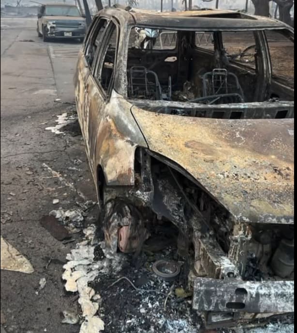
  • Alloy wheels heated hot enough and long enough to run in rivulets.
  • Melted/missing windshield glass.

The narrative of high wind, dry brush and low humidity do not explain the car. It took a direct hit from something while the car in the background did not. Same formula used in innumerable wildfires the past six years. For those who doubt or dismiss that DEWs caused the Lahaina disaster, please watch the video first.

WATCH THE IMAGES IN THIS VIDEO PLEASE; HE EXPLAINS IT SO WELL!

Many thanks to @Dooderonomy for posting the video previously.

=== ORIGINAL POST BELOW ===
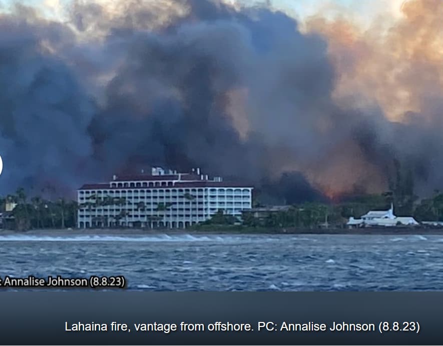
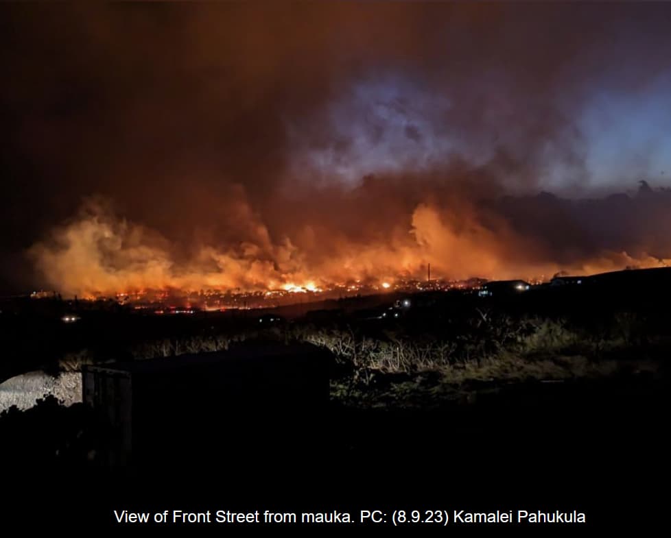
Lahaina and West Maui, Hawaii are burning now; looks pretty bad.

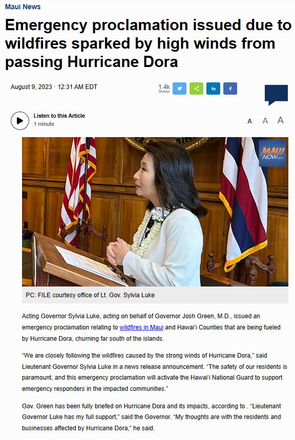
“Update: 1:47 a.m., Aug. 9, 2023. Maui fire crews continue to battle three large wildfires–one in Lahaina, one in Pūlehu that has traveled down to Kīhei; and one in Kula, which has burned more than 1,000 acres since it was first reported early Tuesday morning.”

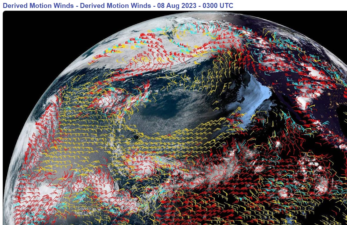
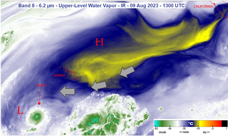
Once again, high winds and embers from an upwind brushfire are sufficient to set a town and other populated places ablaze. Several sources mention Hurricane Dora off to the southwest as cause for the severe wind conditions; one article mentioned the high pressure to the northeast as well.

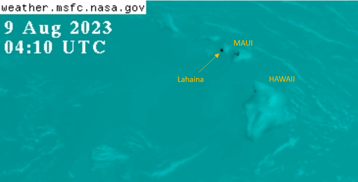
As usual, multiple black dots appeared in the Lahaina area in pretty quick succession.

Despite no one asking, my opinion of the matter:

  • Black dots (hottest surface temp) are ALWAYS created by a DEW heat source
  • Damage in Lahaina will resemble California towns that had totally burned-out houses next to combustible foliage and materials that curiously did not burn.
  • The black dots on western Maui appeared in quick succession, of course. It was windy and conditions were dry.
  • Hurricane Dora provides a GREAT EXCUSE for the high wind conditions.
  • Hurricane Dora was CREATED off the coast of Baja California
  • Hurricane Dora has been STEERED across the Pacific along the equator
  • Hurricane Dora has been SUSTAINED into a precision roller bearing
  • That hot upper tropospheric area (yellow and blue) has been MANAGED to push (high pressure) much harder than Dora has been managed to pull (low pressure)
  • This is but the latest example of sheople fodder supplied by the Climate Change Cabal to herd them and all of us into submission.
8 Likes

Speaking for myself: I do value your opinion of these matters. Thank you.

7 Likes

Wildfires on a tropical island ?

5 Likes

@nperpetuity Thank you kindly. I know I sound a bit dramatic and am too dogmatic at times; I don’t wish to offend or annoy (much like the Climate Change Cabal does to me).

3 Likes

I don’t know if the USA has something similar, but Canada has a “Weather Modification Information Act” which makes interesting reading…

Apparently, according to this legislation, the weather modification activity data could be made available to the public: https://laws-lois.justice.gc.ca/eng/acts/w-5/FullText.html

(It would be interesting to know if someone has asked them to provide a list of who has been engaging in weather modification activities, whether they would actually release that information in accordance with Section 5 of that Act)

And, there is a treaty between USA and Canada regarding the exchange of weather modification activities, also interesting reading: View Treaty - Canada.ca

3 Likes

@sunnyboy Gee, look how far back the acknowledgement of the possibility of geoengineering goes in public legislation. Interesting read. If one were to inquire, I bet the only response would be a link to very recent propaganda about geoengineering proposals to “spray sulphur in the skies to reduce sunlight.”

Thank you for the links.

1 Like

Oh my, yes! Yes indeed. Dora was more than 800-miles away and SPARKED not one but several widlfires on Maui and some on the big island. I think it works kinda like rail car sparking but over water.

1 Like

Thanks for the information that you are posting on this topic.

Bill Vander Zalm former premier of BC is active and vocal regarding chemtrails. Several years ago he submitted a Freedom of Information request to the Federal Government asking for information as to what is being implemented under Canada’s Weather Modification Act Weather Modification Information Act . The government did respond but with a heavily redacted document withholding a lot of information as required to protect “national security”
The links below are to 3 different interviews with Mr Vander Zalm . There is overlap but also unique information in each link.

Latest on BC wildfires is as follows : Of the 1748 Fires so far this Year
404 are Active Fires , 11 Fires in the Last 24 Hours ; 344 Fires Caused by Lightning , 23 Fires Caused by People ,37 Fires with Unknown Causes ; 13 Fires of Note ; 195 Out of Control; 108 Being Held ; 101 Under Control . No end in site , serious thunderstorm activity forecast today in the interior and hotter temperatures coming back at the end of the week.

5 Likes

… just curious … anyone know if H.A.A.R.P. has been powered up lately? Also, was there any scalar radar wave activity (of the circular and square variety), very unusual cloud formations or non-standard frontal movements recorded in the 7 - 10 days leading up to these events?
Just asking for a friend …

1 Like

Oh yes. This is how the tropical jungles in So. America are cleared for roads, ranches, towns, etc.

@sharick Excellent information. Thank you so much!

1 Like

@Scarmoge I can’t speak to HAARP or successor technologies that were deployed for this event. The evidence I rely on is from effects that are discernable in satellite imagery and with the naked eye.

As to the time period leading up to the Lahaina Disaster, yeah, there are two things to note. Development and management of Dora and control of the “high pressure zone” (HPZ) northeast of Hawaii.

Dora is an invented hurricane; I watched it start days ago. They have done this multiple times now, to include Tropical Storm Calvin last month which was walked across the Pacific all the way to Hawaii. Practice run I say. They did this in '21 and '22 and have done Atlantic storms as well.

The link below illustrates well the progress of both Dora and the HPZ. Unlike the other NOAA satellite channels, the Derived Motion Winds goes back several days; in effect, viewers can see farther back in time.

Don’t click on the link though… instead, copy the address, paste it in a browser, remove the missing space then press .

https://www. star.nesdis.noaa.gov/GOES/fulldisk_band.php?sat=G18&band=DMW&length=240&dim=1

That stagnant and cloudless area to the northeast of Hawaii seemed to be the primary mechanism that funneled winds (yellow arrows) to the south and thereby increase their velocity. Dore wasn’t some massive vacuum cleaner pulling air from the eastern pacific while hundreds of miles southwest of Hawaii; else why are so many yellow arrows seemingly passing by Dora (just as they were in previous days)? They tightened that stagnant area up like a sphincter as the winds were channeled toward Hawaii.

Dora certainly factored into area wind flows; however, I contend it was just a convenient, very dramatic and most effective cover to explain them (the very high winds).

I believe this entire, tragic event was well planned. It is evil and quite likely intended to facilitate climate lockdown. Drought, deluge, wind, hail, flood, fire, smoke, etc. Each one seems to exceed the previous. A hurricane has BURNED down a tropical tourist town, killing dozens. What’s next, a wildfire that melts a dam??

7 Likes